 |
| From the viewing platform |
 |
| From the old bridge built in 1902 |
So after we got the bridge covered, we wanted to do a little exploring to include a few hikes. Summerville Lake is really beautiful, 28,000 acres with 60 miles of shoreline. It is very clear water and is surrounded by sandstone cliffs. We found a hike to Long Point, a rocky point on a curve of the lake. It was a pretty nice 4 mile trail in the deep woods, now I should mention while we have been here we have been plagued with rain showers, clouds, and high humidity, so add that to the dense woods, it made for a pretty sticky and buggy trail, but very pretty.
 |
| Our trail |
 |
| Beautiful rhododendrons |
 |
| View from the end of the trail |
 |
| Looking back at Long Point from a viewpoint |
 |
| Pretty rugged |
 |
| Lots of rafting here |
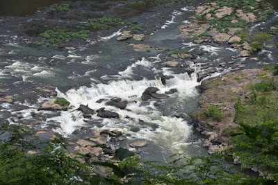
Meanwhile we learned of the Sandstone Falls and there was a gorgeous picture of it in the visitor center. It said it had a nice 3/4 mile loop trail and a picnic area, so off we went with our picnic lunch the next day. It is the largest waterfall on the New River, about 1500' across with a height from 10' to 25'.
 |
| A small view from above |
 |
| Rocky and constantly changing |
 |
| Not a bad spot for a picnic |
 |
| Another view |
The interesting thing about getting there is you have to go south about 7.5 miles past the falls, cross the river and drive back up to the walkway. All good but wow we can tell you, there are NO flat or straight roads in WV! In fact some of the numbered routes are so narrow you can't pass a car without stopping and getting to a spot where you squeeze through!
 |
| A main road in WV! |
So today we went back to the Kaymoor Mine hike, and it was pretty nice, again, the humidity, dripping trees, and the heat made it a bit wet, Karen, you can be glad in a way you weren't able to make it because this was truly "oppressive humidity"! And I was a bit miffed at first as our fairly level hike went right up the mountain for the first 1/2 mile! But it was good and enjoyable.
 |
| A waterfall across the trail |
 |
| One of the mine openings |
 |
| This is a vent and the cold air was just pouring out! |
 |
| Basically, all that is left |
 |
| A view from the mine site |
The vegetation is so thick you can't really appreciate the location of this mine on the face of the gorge like you can out west with few trees to obscure the view. There was a set of steps, 800 in fact that would take you down the 560' feet to the river below, we opted not to do that:-)
Had a nice walk out, all down hill you know. So now we are bracing for more thunderstorms and getting ready to leave tomorrow for Gettysburg.
 |
| A pretty fungus beside the trail |
 |
| Water flowing everywhere |


No comments:
Post a Comment